The Geography of Stalingrad: August 1942
Late in August of 1942 the German Sixth Army bore down on Stalingrad. The German commander, General Freidrich Paulus, had much to contemplate regarding how he would approach the task of seizing the city that would become the bane of his existence and end his military career in catastrophic fashion. Stalingrad sprawled down the broad Volga River's western bank in a long (at over 25 miles) strip of land. Problematically for it's defenders, the Volga's western bank rose significantly higher than it's east bank. Thus, whoever controlled Stalingrad had a dominating view across the Volga and well into the seemingly endless steppe to the east.
That said, because a significant portion of the city was tucked into the low ground under these heights it was difficult for an attacking army to bring direct fire to bear on the city blocks just west of the Volga. That meant any army defending Stalingrad would have a somewhat sheltered final defensive position to serve as it's base for shuttling men and war material into the remainder of the city. In addition, geography aided the defender's in several other ways. First however, let's discuss several key man-made obstacles confronting the German Sixth Army within Stalingrad.
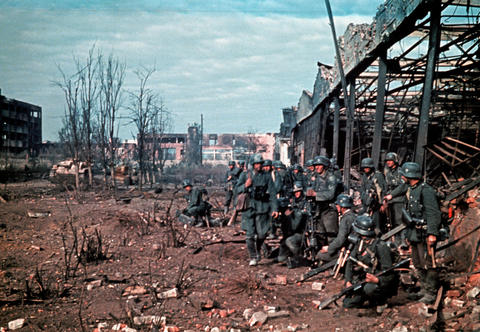
Four massive factories dominated the northern portion of Stalingrad as follows and running from north to south: the Dzherzhinsky Tractor Factory (which would crank out T-34 medium tanks even well after battle was joined in Stalingrad), the Barrikady (Red Barricade) Gun Factory, the Red October Iron Works, and the Lazur Chemical Factory. Worker villages ran to the west of these factories. Further west yet flowed the Mechetka river, a deep ravine, and several suburbs; all bolstering Stalingrad's industrial works as defensive positions and making it that much harder to approach no less attack the factory district from the west. Furthermore, numerous smaller factories dotted the northern part of the city; all of which were more than capable of becoming miniature versions of the fortresses the four large factories ultimately became. Couple that with the city's sheer size all backed by the broad Volga and Stalingrad was far from an easy objective. As such an army couldn't just encircle and besiege the city, it had to fight into it from the north, west, and south; with every step east bringing the attacker deeper into the city's built up areas. On the other hand, Stalingrad contained many wide boulevards and open parks conducive to operating armored formations within the city (contravening normal practice to avoid the use of such units in a city).
Further south and halfway between the factory district and city center stood the 300 plus foot high Tartar burial ground known as the Mamaev Kurgan. Not only was this a prime observation point and defensive position in its own right, but several topographical features made assaulting the Mamaev Kurgan's slopes that much more difficult. Three deep ravines guarded the Mamaev Kurgan's northern and southern flanks. Stretching east to the Volga these ravines offered concealment for reserves and reinforcements arriving from Stalingrad's main landing stages on the Volga.
In the city center just south of the Mamaev Kurgan was the main train station along with built up areas offering additional strength as defensive positions. Stalingrad's center featured numerous stoutly built apartment blocks and buildings each of which would be turned into well fortified strongpoints in the fall of 1942. Moreover, here as well geography provided a further assist to the 62nd Army that would become Stalingrad's primary protector. The Tsaritsa River protected the city center from being easily attacked from the south. The river was located in a deep ravine that ran east to the Volga and also served as another avenue for the 62nd Army to bring up men and supplies delivered by the flotilla of Soviet vessels gathered in the Volga. Yet another river provided flank protection to the southern part of Stalingrad, as did a huge grain silo (elevator) as well as numerous large buildings and warehouses running between the silo and the railway tracks leading to the city center.
Because of Stalingrad's accordingly unique layout the best way into the city quickly became obvious. Paulus sought to have the XIV Panzer Corps penetrate south along the Volga from where it had reached Stalingrad's northern suburbs. Meanwhile the LI Army Corps would strike from the west, driving the Soviet 62nd Army before it. Fourth Panzer Army's XXXXVIII Panzer Corps would penetrate the city from the southeast while pounding through the Soviet 64th Army. As previously mentioned Sixth Army's XIV Panzer Corps, though ordered to attack the imposing factory district, faced initially the weakest opposition in the city. Nevertheless, the Stalingrad Front's pressure on XIV Panzer Corps flanks hindered Paulus' plan of attack from the moment the 16th Panzer Division reached the Volga. This allowed the reeling 62nd Army to fall back into the city and regroup. All of which led to the epic struggle that many to this day refer to as the defining moment of the greatest war in history.

Post new comment