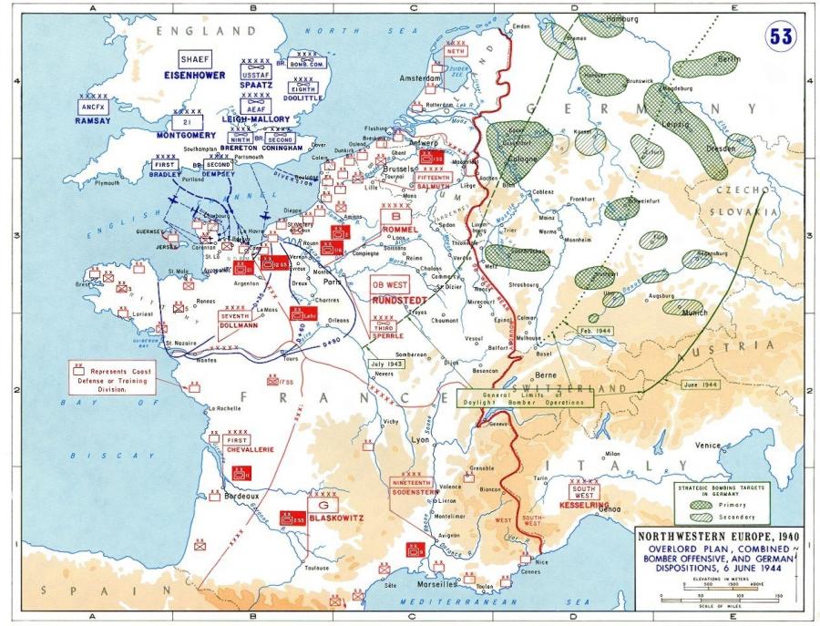
Planning for Operation Overlord: German dispositions on June 6, 1944
Initially Germany approached the problems inherent in defending occupied France as largely one of preventing special operations conducted by the British. Such a German approach was understandable given Britain's best units remained tied down in North Africa during 1941-43. Nonetheless, Hitler's declaration of war on the United States, coupled with Barbarossa's defeat and the Soviet Union's resilience meant it was only a matter of time before the Anglo-American armies struck Nazi occupied Western Europe. To direct the German defensive effort in the west, Hitler turned, in the spring of 1942, to Field Marshall Gerd von Rundstedt; idled since his November 1941 resignation as commander of Army Group South on Germany's Eastern Front. Rundstedt took over a command in France plagued by numerous problems. Most noticeably, the German leadership featured an all too common top-level dichotomy. This schism eventually fed the 1944 German debate regarding the appropriate strategy for dealing with an allied invasion; a rupture never truly resolved, with the resultant half-measures crippling German defensive efforts.
After taking over the German army's in France Rundstedt in particular became tremendously concerned about the pitiable state of his "army." Rundstedt's concern in regards to his command resulted in an October 1943 inspection report which he sent to Hitler. Rundstedt's report requested greater authority over military assets in the region, as well as detailing a woeful shortage in fuel, heavy weapons, ammunition, and quality personnel. In addition, Rundstedt's report also and perhaps most critically narrowed the expected Allied invasion sites to three possible areas. The expectations created by this assessment would have profound implications for the disposition of the German armies in France during the spring of 1944. What the report did was single out the Pas de Calais area as the foremost location to expect an allied invasion - a logical choice given the region's proximity to England. However, the report also highlighted potential landing sites along the French Mediterranean coast in conjunction with potential attacks in the Bay of Biscay - a vast region stretching all the way to the Spanish border. Lastly, Rundstedt singled out the beaches in Normandy and Brittany as potential Allied invasion sites.
The legacy of these decisions is evident when one examines this map. In looking at the German dispositions one sees the results of a command apparatus that never really made up their minds where they thought the Allies would strike. The Germans never even really organized their armies around properly defending their top choices for an expected Allied invasion. Thus, several elements had worked to undermine the German defensive effort. First, was the failure to limit the scope of potential invasion sites early in the process; although this can also be attributed to a brilliant Allied deception effort in regards to where the invasion force would land. Second, in November 1943, when Hitler appointed Field Marshall Erwin Rommel to prepare the "Atlantic Wall" for repulsing the Allied invasion, in spite of Rundstedt's continued presence, the Germans had only
further disorganized their command. The bifurcated German command apparatus meant competing theories revolving around how to stop the Allies were never truly resolved. Up to June 6, 1944 German planners remained split in regards as to whether they should attempt to smash the Allies on the beaches or fight the Allies in the French interior.
Consequently, Germany's best defensive assets; including the ten panzer and panzer grenadier divisions in France on June 6, 1944 are scattered all about. Had Hitler, OKW, Rundstedt and Rommel ever resolved their numerous differences and even a third of the panzer/panzer grenadier divisions in France been concentrated near the Normandy beaches on June 6 1944 then the D-Day victory celebrated every June in the sixty-five years since this fateful day may not have occurred, and the world could look very different today.
Map Courtesy of: Department of History, United States Military Academy


